

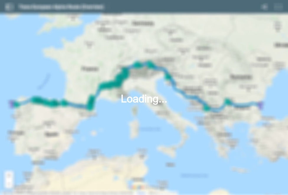
Thru-hike a continent.

The Trans-European Alpine Route crosses mainland Europe by traversing 6 major mountains systems.
It passes through 16 countries, 16+ national parks, and is roughly 6250km long.
It can be hiked in a single continuous trip with 3 season gear, if you’re up for it.

Status / Goals
The Trans-European Alpine Route (TEAR) is not an official hiking trail. It has no recognition, no governing body, no signs or blazes. It’s just an idea – a possible framework to cross Europe through the mountains by using existing trails and infrastructure. While there are other proposed routes which cross Europe (E3, E4, etc), unfortunately no existing path attempted to pass exclusively through the high mountains.
I’ve created a route which tries to balance the many considerations of long distance hiking – scenery, tread, navigation, resupply, etc., while spanning the breadth of a continent. The overall length of the route was an important limiting factor, as there are obviously many beautiful places along the way which are not explored in order to preserve the possibility of a full hike within the fair weather window.
Route
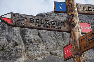
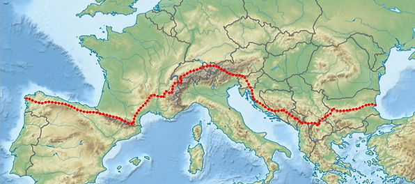
Beginning on the coast of the Black Sea and ending at the Atlantic Ocean, the TEAR offers a complete east-west traverse of southern Europe. The current route pieces together 30+ named trails either in part or in full. Some are already composite 'mega-trails' themselves, such as the Via Dinarica and Via Alpina networks. Signage is inconsistent at best.
I’m open to suggestions for improvements to the route. Dozens of possible alternates, both small and large, are already included in the GPS data for each section.
Sections
It’s easiest to conceptualize the TEAR into 7 distinct sections, based on the 6 mountain systems it traverses (and a gap between two of them). The dedicated pages for each section are linked below, but I'd recommend continuing with the rest of the overview first.
1. The Balkan Mountains (555km)
2. The Balkan Gap (504km)
3. The Dinaric Alps (1261km)
4. The Alps (1656km)


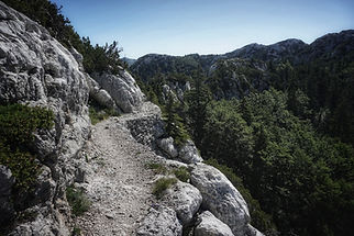
Terrain
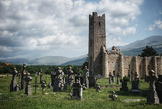
The terrain throughout the TEAR is highly varied. While mountain and forest scenery tends to dominate, there are also coastal views, scrubland passages, and areas of farmland or pasture.
Trail Conditions
Just about every type of track exists somewhere on the TEAR, from paved roads to pristine single track to open cross-country travel. Calculating the overall breakdown of the different tread surfaces is an ongoing project, but for now there are general descriptions within each section. Some trails are steep and rugged while others are smooth and gradual. Although there are some short scrambles as well as several short and simple glacier crossings, the TEAR remains within the scope of hiking and specialized climbing/mountaineering gear is not needed (helmet, harness/rope, crampons, ice axe, etc).


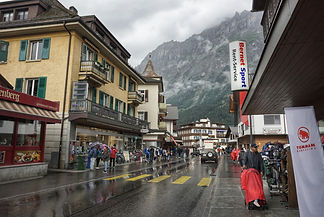
Weather
The ideal weather window for a westbound hike of the TEAR (with 3 season gear) is generally from mid-April to mid-November, although conditions will vary from year to year. Within the first two weeks you will rise from sea level to elevations over 2000m and lingering snow will be encountered in the higher elevations of the Balkan Mountains, and then again further on atop the Sharr Mountains and southern Dinaric Alps. Extended travel on snow should be mostly avoidable with low route alternates. The crux on the western end of the route is traversing the Pyrenees before winter snows arrive in late October. After the Pyrenees the hiking season is extended across northern Spain thanks to the lower elevations and the proximity of the Atlantic. On this schedule a hiker should be prepared to camp with overnight temperatures down to slightly below freezing, and to hike in cold rain during the day. Thankfully, the coldest weather will be encountered during those first and last sections of the TEAR where shelters, huts, and hostels are common. Summer temperatures in the Alps, on the other hand, are wonderful.
Wild Camping Regulations
To the best of my knowledge, the hiking route stays on public land where there should be no restrictions on walking. Sleeping becomes more complicated. In most countries 'freedom camping' is technically illegal, but if done discreetly and responsibly it's usually not a problem. In Europe a distinction is usually made between a campsite and a bivouac. The former implies a structure that is left up during the day, while the latter implies a small, temporary resting place only for the night. A simple bivouac between dusk to dawn on uncultivated land is usually tolerated. Specific parks and protected areas will also have their own rules regarding access and camping, which are noted in the GPS files for each section. Mountain huts are an option in many regions. Always ask landowners politely when you find it necessary to camp on private land, and always Leave No Trace.


Water
Finding water is not a significant problem on the TEAR, but outside of the Alps and Pyrenees you should always have an idea of where the next likely water source will be. A capacity of 4-5L should be sufficient for the occasional 20km water carry or dry camp. Water sources that seemed reliable have been marked on the GPS data provided, but I make no guarantees. Springs can go dry and cow troughs can break. You are responsible for your own safety. If your primary method of water treatment fails it may be some time before you can replace it. Carrying a simple backup (chemical treatment, etc) would be prudent.
Resupply
Download the resupply spreadsheet here. There are separate sheets for each section. After downloading it you can make adjustments to your expected pace for each section and the required days of food from each resupply will change accordingly. Notice the business hours where available and your expected day of arrival.
Most resupplies are on trail and distances between them are relatively short, resulting in food carries of 2-4 days on average. There are a few larger stretches, the longest being 177km of fairly fast terrain. You will likely not have to mail a single food resupply unless you are picky or have very specific dietary needs (I hiked the entire route as a vegan without a single food drop, but I’m content with a repetitive diet). Standard backpacking fare of pasta, couscous, oats, bread, chocolate, dried fruit, nuts, candy, cookies, dried meat, and cheese are all widely available throughout Europe. Ramen and peanut butter are hit-and-miss so enjoy them when you can. Business hours for each resupply stop have been included as per 2020 Google Maps data. Many shops are not open on Sundays, so plan accordingly.
Fuel
Threaded isobutane fuel canisters are not commonly available in Europe outside of outdoor gear stores, which are often only found in larger cities. A short side trip to replace your shoes and fuel canister can be done easily to Sofia (Bulgaria), Split (Croatia), Grenoble (France), Valence (France), Perpignan (France), and Pamplona (Spain) via public transportation. If you tend to burn through fuel canisters, you may want to consider using a multi-fuel stove.
Another option is to carry a small alcohol stove as a backup to a canister stove, since denatured alcohol can usually be found in some form in general stores, hardware stores, or pharmacies (relying on it as your sole fuel source isn’t ideal since it’s usually sold in large bottles and there will be no other hikers to share with, making it wasteful or unnecessarily heavy). Cold-soaking, no-cook foods, and hot meals at huts or restaurants can also be incorporated into your resupply strategy to stretch your fuel farther.


Navigation
Although many of the trails used on the TEAR are blazed, having some sort of map/GPS is absolutely essential for navigating the countless unmarked intersections you'll encounter. The GPS data provided for each section can be exported from Google MyMaps and loaded into offline navigation apps such as Gaia. I recommend downloading and then uploading each layer of each section separately, and then recombining them into a proper folder structure within Gaia, which will allow you to toggle the visibility of each subfolder/layer. For example, sometimes you’ll want to see the 1km waypoints to measure a distance, but most times they’ll just be in the way.
The topic of physical maps will be controversial. I have not created a mapset for the TEAR, although it could certainly be useful. With 6300km of coverage it would be unrealistic to carry a complete set of maps from the start, and crossing 16 countries each with differing postal systems would add an additional layer of logistical challenge to your planning (General Delivery or Poste Restante services are not always available). I strongly encourage some form of redundancy in whatever form of navigation you choose, whether it’s a separate GPS unit or even an additional cheap smartphone. An external battery pack will not suffice if you drop your phone on a rock.
I should also note that the wilderness corridor in southern Europe is nowhere near as vast as what you might find in the western USA, and even with full reliance on digital maps I was never worried about becoming stranded during my hike. If all your navigational resources were to suddenly fail for some reason, heading downhill on any trail would likely lead you to a road, which would then lead you to people. Few areas in southern Europe are completely empty.
Wildlife
The ones that are nice to see: Ibex, chamois, marmots, foxes, griffon vultures, alpine salamanders
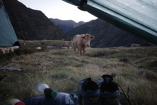
The ones you'll get tired of seeing: Cows, sheep, horses, dogs
You'll constantly be sharing the trail with livestock and their waste. It's better if you know now. Sheepdogs are quite common in Europe and are very protective of their flocks. Although they're loud and large, you shouldn't have any problems as long as you move calmly while giving them and their sheep a wide berth.
The potentially dangerous ones : Common Adder, Nose-horned Adder, ticks
Europe's poisonous snakes are not aggressive and bites are rarely fatal, but you should always keep an eye on the trail regardless. Ticks can carry lyme disease or tick-bourne encephalitis so long clothing, bug spray, and daily checks are advised in warm or brushy areas. Austria vaccinates against tick-bourne encephalitis.
The ones you don't have to worry about: Bears, wolves, flying insects
Although there are small populations of bear and wolves in some of the areas you'll be passing through, they generally avoid humans and the chances of an encounter are very low. Thanks to the combination of geography and timing on a TEAR thru-hike there are also surprisingly few mosquitoes or biting flies, but perhaps I got lucky.


The Schengen Area
**DEC 2023 UPDATE: Bulgaria has now also joined the Schengen zone, making a continuous single-season thru-hike of the TEAR all but impossible for non-European hikers. The border restrictions in Bulgaria will be lifted in two phases, beginning with air and sea entries in 2024. It appears the shared Shengen visa rules will be applied immediately.**
**JAN 2023 UPDATE: As of Jan 1, 2023 Croatia has now entered the Schengen zone of Europe, making a continuous thru-hike of the TEAR even more difficult for non-Europeans. I hope to update this section with new recommendations soon, but for now the next few paragraphs should be considered outdated.**
The biggest travel issue is the Schengen Area of Europe – a group of countries with shared borders and common visa or visa-free regulations. Here's a map. This arrangement is a huge benefit once you enter Slovenia, since you can then cross back and forth across borders up in the mountains without registering at official entry points. The problem is that a regular tourist visa (or visa-free allowance) only allows you to stay in the Schengen Area for a maximum of 90 days in any 180 period. This is not enough time to travel the final ~4000km of the TEAR. This leaves a would-be thru-hiker with three options:
1. Apply for a separate VISA to Spain, such as a working-holiday VISA.
Citizens of Canada, Australia, New Zealand*, Japan, and South Korea, aged 18-30, can apply for a Working Holiday Visa which will allow you to stay up to a year in Spain while occasionally working. The requirements differ for each country. You will reach Spain after ~2400km of hiking through the Schengen Area, which can reasonably be done within the 90 day limit. Once you enter Spain you will then be staying under the terms of you Working Holiday Visa. You won't be able to legally re-enter the Schengen area, so you can hike the GR11 across the Pyrenees which allows you to stay within Spain for the remainder of the journey (you'll pass through Andorra, but it's not part of the Schengen Area and has no visa requirements). Since you'll be finishing late in the year, you can even take full advantage of your visa by spending your winter in Spain's sunny southern coast.
*It seems New Zealand has agreements with several European countries (including France and Spain) which pre-date the Schengen agreement and allow them to stay within these countries for up to 90 days each, effectively solving the Schengen issue for the TEAR. Lucky Kiwis.
2. Keep hiking past the 90 day allowance and risk the consequences.
If you are caught overstaying a Schengen visa (or visa-free allowance) you can be fined a maximum of 1200EU, be deported, and may have trouble entering Schengen countries in the future. Or, maybe nothing will happen. Unless a police officer or other government official has a reason to look at your passport your only concerns will be at the airport upon departure from Spain. Spanish customs officials have a reputation among travelling forums to be fairly lax with overstayers who are already on their way out of the country, but there are no guarantees and you could easily be hit with the full penalties. It's your risk and your passport on the line. Research the topic of overstaying a Schengen Visa online and make your own decision.
3. A Flip-Flop hike
Obviously section-hiking the TEAR in multiple trips would solve the Schengen issues addressed above, but if you're committed to completing the TEAR in one continuous attempt there's an additional option. By changing the hiking order of the sections, you can still trace a continuous footpath across Europe without leaving for the winter. You could start at the western terminus (Cape Finisterre) in early March and hike Section 7 eastbound across northern Spain towards the Pyrenees. If there's still too much snow in the higher Cantabrians for the main route you could walk the Camino Norte in reverse along the coast towards Irun/Hendaye. Next, you'd skip the Pyrenees and take the bus/train to Vinca to hike Section 5 (Massif Central) eastbound. After reaching Valence you'd travel to Bulgaria and finally begin hiking westbound from Cape Emine in late April. You'll want to keep a fairly relaxed pace through Sections 1, 2, and 3 to ensure you spend a full 90 days outside of the Schengen Area. When you re-enter the Schengen Area at the end of Section 3 you'll have 90 days to race across Section 4 (the Alps) and then jump over to Section 6 (the Pyrenees) to close the final gap. These are the two most difficult (and scenic) stretches of the TEAR and completing them both in 90 days will be tough, but possible.
In summary: Section 7 and Section 5 (early season), Sections 1-3 (min 90 days outside Schengen Area), Section 4 and Section 6 (Max 90 days in Schengen).
1
1
7
7
6
6
5
5
4
4
3
3
2
2
For US citizens: There's a pre-Schengen agreement between France and the USA which allows US citizens to stay for an additional 90 days after the Schengen allowance, on the condition that you must afterward leave the Schengen Area for 90 days before re-entry. This doesn't help with a continuous hike of the full TEAR because it requires you to end your trip in France, but you could hike a slightly shorter version which ignores Section 7 and continues across the last of the Pyrenees to reach the Atlantic at Hendaye. This would still be an epic and worthwhile thru-hike. You could also hike the entirety of the TEAR by simply hiking Section 7 first (perhaps start/end at Hendaye) and then heading to Cape Emine to start a normal westbound hike all the way back to the edge of Spain. This way you can effectively split the trip into two separate coast to coast hikes which combine to span the full width of the continent. For Section 6 (The Pyrenees) you'll need to stay on the French side of the border which can easily be done by following the GR10 (and any French parts of the HRP). If you're worried you won't reach the Pyrenees until too late in the season you could hike them before Section 5 (Massif Central) which is still contained in France and sits at lower elevations. This allows for the longest hiking season and most relaxed pace of all the options mentioned.
In Summary: (early April start?) Section 7, Section 1-6 OR Section 7, Section 1-4, Section 6, Section 5


Challenges
There are several main challenges that you should consider before attempting a thru-hike of the TEAR. They can be summarized as the 4 L’s:
Long days
The TEAR is considerably longer than any of the US triple crown trails. Its average elevation change is also greater (yes, slightly more than the AT). A thru-hike of 7 months requires an average of 29km (18mi) per day, along with an average of 2300m (7600ft) combined elevation gain and loss per day. This does not include zero days. Pack light.
Logistics
Would you be comfortable not knowing where you’ll be able to sleep tonight? Consider that you often can’t just lay down wherever you happen to be at the end of the day (an inhabited valley/village), and rarely are there established wild campsites to aim for like you find on many US long trails. When shelters or huts aren’t available you’ll need to plan ahead and use your maps to identify potential bivy locations while constantly adjusting your plans due to changing conditions and unforeseen circumstances. It’s an adventure.
Loneliness
Unless you plan to travel with a partner or small group, expect to spend most of your time hiking and camping alone. During the summer months there will be plenty of people on the trails in the Alps, but otherwise your paths will be very quiet. Don't expect to find any other TEAR hikers, I don't even know if anyone else is ever going to attempt this. No one you meet along the way will know what you’re doing, but most will be baffled and excited to hear about it. The generous hospitality you’ll occasionally receive will be much appreciated.
Language
The TEAR passes through 16 countries, none of which have english as an official language. Expect to face a language barrier when communicating with locals, although english is becoming increasingly common. Your chances will be greater in urban areas and with younger people. Google Translate is your friend. Download the offline data for all of the languages you’ll encounter, and learn some basic greetings and vocabulary as you enter each new region. Body language and pictures go a long way. I laminated a simple map of the TEAR with a picture of a hiker on it which I used many times to communicate what I was doing.


Cost
Like any long journey, expenses will vary wildly according to your tastes and comfort requirements. Although Europe has a reputation for being expensive, the standard US ‘on-trail’ thru-hiking budget of 1-2$ per mile can still be achieved by purchasing food from supermarkets and avoiding paid accommodation whenever possible. This is in stark contrast to the hut-to-hut hiking culture which is the norm in most of Europe. With unlimited funds you could travel very light indeed on many stretches of the TEAR, but I doubt this is the case for anyone reading this page. Restaurant meals (including huts) and hotels (including huts) add up quickly, and these spending opportunities are much more frequent in Europe than on other trails. Watch the forecast and try to plan your rest/laundry/shower days to coincide with poor weather. This limits your excuses not to camp.
This also brings up another interesting distinction between the TEAR and other long distance trails – resupply locations and shower/laundry opportunities are not necessarily coupled with each other (the latter is more common due to staffed huts and campgrounds). Since you’ll be walking to virtually every resupply, it’s easy to just stock up and keep moving while postponing the rest of your ‘town chores’ for another time. Many mountain huts have hot showers and you can usually do some simple laundry in the sink. This flexibility makes it possible to move quickly, cheaply, and comfortably.
The Trans-European Alpine Route
Hike Across a Continent
(First Edition, Hardcover)
The resources needed to plan your own hike along the TEAR are provided freely on this site for anyone who is interested. Head to each of the individual sections for downloadable GPX data including tracks, water sources, resupply locations, variants, etc.
However, if you'd like to support the project and receive a beautiful 'coffee table' style book guiding you throughout the route, you can order here. The book contains over 300 colour photos and is packed with details about the beautiful and interesting places along the route.
Note: The books are printed-on-demand as they are ordered, which allows them to be printed closer to your location and saves on worldwide shipping costs and emissions. However, this means they require a couple weeks before they can be shipped. Thanks for your patience!
