
In 2016 I hiked from Mexico to Canada along the Continental Divide Trail.

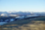
The CDT is a monster of a mountain adventure. The concept for the trail is a great indicator for what you're up against - you'll be straddling the high ridge that divides the watersheds of North America between the Atlantic and Pacific. The trail does a surprisingly good job of keeping you on that line whenever possible. Although it's an amazing thought that the rain falling on your left is destined for a different ocean than the rain falling on your right, most of the time you'll be too distracted by the sheer beauty of the surrounding landscape to think anything but, 'Wow.'
What sets the CDT apart from the PCT is the 'incompleteness' of the trail and the number of variants that become possible. The tread itself varies from single track to forest roads to no trail at all. Endless 'alternate' options are shown on the most popular map sets, and allow for infinite variation in your personal path through the Rockies. Some go to higher ground and suggest you scramble up to a nameless ridge for a beautiful view, while some might go low onto forest roads as a bad weather option. My approach was to always take the most scenic route, and when I couldn't decide what looked better I'd take the shorter one. HYOH.
---
Roughly a month after reaching the end of Te Araroa I found myself at the US/Mexico border again - this time in New Mexico, at the southern terminus of the Continental Divide Trail. At that point I had been travelling abroad for over 9 months, and there had been many times in New Zealand that I missed my family and friends dearly. I had been on the fence between hiking the CDT or just going home, but finally resolved to hit the trail. I had just enough left in my budget to last the trip and no responsibilities to get back to; when else would I have such an opportunity? As soon as I took my first steps from the dusty border fence I knew I had made the right choice.
CDT thru hike video below.
(May take a moment to load)
By the Numbers
Length: 2600-3100 miles (Many variations are possible, my route was 2800 miles)
Start: April 24th (Mexican Border)
Finish: Sept 28th (Canadian Border)
Average Pace: 17.7 mi/day (Including rest days)
Longest Hiking Day: 37 miles (twice)
Shortest Hiking Day: 3 miles
Longest stretch off the official CDT: 200+ miles through Wyoming (WRR High Route + Gros Ventre Wilderness + Tetons)
Longest distance at Elevation: 25+ miles above 12000ft (approach to Grays and Torreys via Argentine Ridge)
14'ers Climbed: 4 (San Luis Peak, Mt Elbert, Grays Peak, Torreys Peak)
Practical CDT Info and Resources:
A Quick and Dirty Guide to the CDT


