
The Balkan Mountains (Kom-Emine)
Section 1 of the Trans-European Alpine Route
This section of the TEAR simply follows Bulgaria's longest and oldest trail, the Kom-Emine, for it's entire length across the Balkan Mountains. The eastern terminus of the trail, along with the entire TEAR, is Cape Emine, where the Balkan Mountains rise out of the Black Sea. The Kom-Emine winds its way towards Kom Peak (near the Serbian border) along a network of dirt roads and walking paths (official estimates are 70% forest/farm tracks, 20% single track, 5% paved).
The Balkan Mountains, or Stara Planina, run east-west across central Bulgaria before curving north and forming the border with Serbia at their western end. They have played an enormous role in the history of Bulgaria and even provide the basis for the name of the entire Balkan Peninsula.
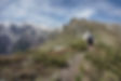
The highlights of the Kom-Emine are the high ridge walks along the western and central sections of the Balkan Mountains (including the Central Balkan National Park), although this also presents the greatest challenge for TEAR hikers due to the lingering snow and unsettled weather in the early spring season. Thankfully a well established system of mountain huts allow for options for weary walkers to dry off and warm up.
GPS Notes: The track shown here is the one provided by the official Kom-Emine website, not one I recorded myself. It may not perfectly match the marked trail on the ground and sections may be overgrown (especially in the eastern Balkans).
Export GPX Files: Click the Fullscreen button (top tight), then in the Legend (left), then click on the three dots beside the map title and select Download KML. I suggest downloading only one layer at a time, so that the files will be organized into separate layers when you import them into your offline navigation app.
Main Route
Conceptually, navigation for this section is fairly simple since we're sticking to a single trail the entire way. The Kom-Emine is generally well marked with blazes of red and white stripes, although sometimes an important intersection will have nothing while a clear forest trail could be blazed on every other tree.
There is an official guidebook available (be sure to order the english version) which contains additional historical and cultural details, daily trail descriptions, hut information, and overview maps (not detailed enough for navigation). It's important to note that the trail is traditionally hiked eastbound, from Kom Peak to Cape Emine (this is the way the guidebook is written), while you'll be hiking in the opposite direction.


Alternate Routes
There are several official alternate routes along the Kom-Emine which allow you to bypass the main (exposed) ridges during bad weather. You'll likely encounter snow anywhere above 2000m in April so these trails become very useful options. Unfortunately there is no alternate around the highest point of the Balkan Mountains, Botev Peak (2386m), so you'll have to brave the elements.


Resupply
The Kom-Emine doesn't pass through many towns due to its path along the main ridges of the mountains. This means you'll have to drop down off the trail to the plains below if you want to restock at a market (these are still small towns so don't expect much variety). There is a fair amount of flexibility with resupply strategies here since you could also opt for longer food carries or supplement your resupply with meals from the many huts along the way. Some of the huts may be closed or have limited services during this time of the year so plan carefully. The schedule given on the resupply spreadsheet is a good balance of limiting off-trail resupply miles and food carry distances. The GPS files include some additional options as well.
There are no places along the trail to buy a threaded fuel canister. You'd have to hike south from the mountains and catch a bus or train to Sofia. The only place where you can catch a train directly from the trail is Gara Lakatnik, after 500km of hiking. You can also take a train into Sofia early in the next section. Denatured alcohol (СПИРТ) can often be found in general stores and is purple.
Water
Most sources should be flowing well early in the year. The sources mentioned in the GPS data are not exhaustive and often don't include obvious sources such as larger rivers or towns. Water can also be acquired at most mountain huts (check hut descriptions in Huts/Shelters info). Possibly the longest water carry of the whole Kom-Emine begins only ~3km after leaving Cape Emine, which may require carrying for the rest of the day and a dry camp. Thankfully the temperatures should be cool and the early terrain is easy.


Huts / Shelters
There are many staffed huts along the route as well as unstaffed shelters in various conditions. Wild camping is not permitted within Central Balkans National Park, but there are many huts and shelters for the ~100km of trail through the park.
Borders / Transportation / Other
The most important information here is how to get to Cape Emine. Burgas has the closest international airport, but I haven't been able to confirm a place to buy threaded fuel canisters for your first resupply. Sofia certainly has them, so you could fly there and take the train to Burgas. Eastern Europe is very easy to explore on a budget, so feel free to travel a bit before hitting the trail. Regardless of how you get to Burgas, you'll then need to take a bus north to Sunny Beach. During the summer the local bus lines in Sunny Beach extend all the way to the Elenite resort area, but in the early season you'll have to walk most of the way or flag a taxi (ask the price beforehand so you don't get ripped off). From Elenite it's a 10km hike to the village of Emona, which has a small hiker-friendly bar/restaurant. I humbly suggest having at least a drink there before walking the ~2km to the Cape and finding a place to camp above the cliffs. In the morning you can watch the sunrise over the Black Sea before setting off.


Next Section: The Balkan Gap